
DULUTH, Minn. — It feels like there is no middle ground when you live in Minnesota. Winter either brings a ton of snow, or — as evidenced by the winter of 2023-24 — none at all.
And now, after years of drought conditions that had folks praying for rain across much of the state, we have plenty. In fact, more than folks can handle.
Tuesday was off the hook in most of northern Minnesota, with a powerful evening storm system dropping more than half a foot of rain in some spots. KARE 11's John Zeigler said a warm front and extremely high moisture led to a nasty meteorological set-up in the north and northeast, with supercell thunderstorms quickly turning into clusters of very hard rain across the north woods. The main problem with these storms, Zeigler explained, is the cell's northeast movement allowed for the storms to "train" each other - lining up one after the other to hit the same area over and over.
Preliminary reports are staggering, with one measurement near Ely coming in at 7.3 inches, and a spot north of Silver Bay on the North Shore reporting 6.5 inches. Here are some of the other rain totals from the north country.
- Marble - Itasca County - 7.30
- Tofte - Lake County - 5.30
- Hoyt Lakes - St. Louis County - 5.20
- Biwabik - St. Louis County - 4.96
- Chisholm - St. Louis County - 4.91
- Silver Bay - Lake County - 4.85
- Iron Junction - St. Louis County - 4.54
- Grand Rapids - Itasca County - 3.61
- Grand Marais - Cook County - 2.90
- Park Rapids - Hubbard County - 2.86
- Duluth - St. Louis County - 2.63
- Bovey - Itasca County - 2.63
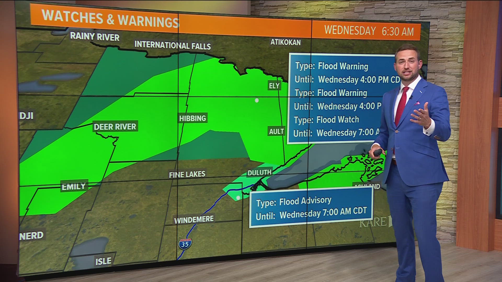
While the Flash Flood Warning issued for northeastern Minnesota has expired, a more general Flood Warning remains in effect for the region through 4 p.m. Wednesday. While today's forecast appears to provide a reprieve of sorts, rain and thunderstorms will likely elbow their way back into northeastern Minnesota both Thursday and Friday.
A number of highways and county roads are either completely or partially closed until the floodwaters recede.
Most of the Twin Cities metro received less than an inch of precipitation Tuesday, but it was still enough to push some rivers and streams a bit closer to flood stage. Hot spots include the St. Croix River in Stillwater, the Mississippi River in downtown St. Paul and the Crow River in Delano. Minnehaha Creek is also running fast and creeping up over its banks due to the rainy stretch we're experiencing.
WATCH MORE ON KARE 11+
Download the free KARE 11+ app for Roku, Fire TV, Apple TV and other smart TV platforms to watch more from KARE 11 anytime! The KARE 11+ app includes live streams of all of KARE 11's newscasts. You'll also find on-demand replays of newscasts; the latest from KARE 11 Investigates, Breaking the News and the Land of 10,000 Stories; exclusive programs like Verify and HeartThreads; and Minnesota sports talk from our partners at Locked On Minnesota.
- Add KARE 11+ on Roku here or by searching for KARE 11 in the Roku Channel Store.
- Add KARE 11+ on Fire TV here or by searching for KARE 11 in the Amazon App Store.
- Learn more about the KARE 11+ app for Apple TV in the Apple App Store.
- Learn more about KARE 11+ here.
Watch more WeatherMinds:
Watch the latest deep-dives and explainers on weather and science in our YouTube playlist: