MINNEAPOLIS — Many of us could see the biggest snowfall of the season so far throughout Minnesota and western Wisconsin.
The forecast includes snow of up to an inch an hour, howling winds and blizzard conditions.
Here are some answers to the most common questions we're seeing from our audience as they prepare for the blizzard.
When does it start?
The storm system started encroaching on southwestern Minnesota shortly after 8 a.m. on Friday. The snow line reached the Twin Cities west metro around 1 p.m. The heaviest snow should end around 7 p.m. Snow could continue to fall through the night, and fully wrap up early Saturday.

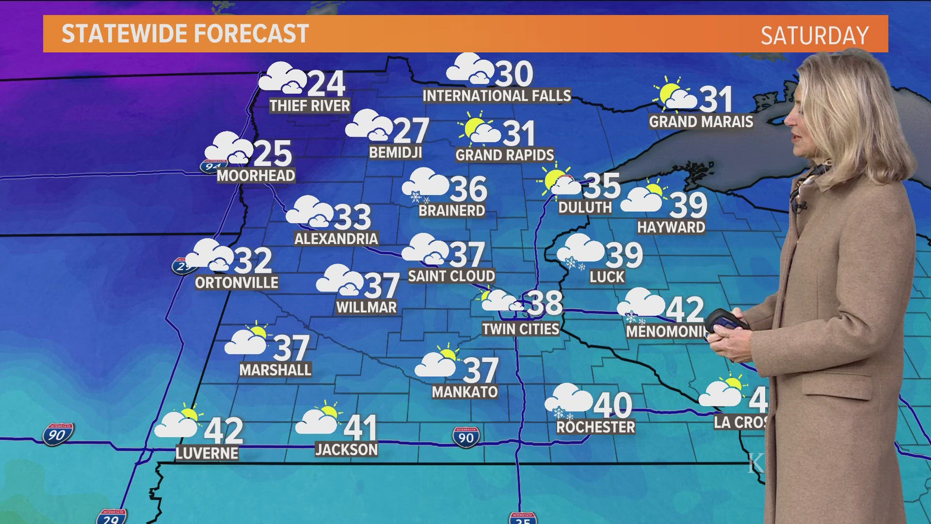
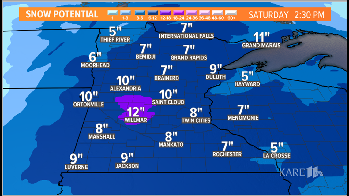
How much will it snow?
The heaviest snow looks like it will be just west of the Twin Cities. Much of Minnesota and western Wisconsin will see 5 inches or more. In the Twin Cities, 6 to 9 inches is likely. Projected snowfall in Willmar is looking the deepest, with 12 inches possible.

How cold will it get?
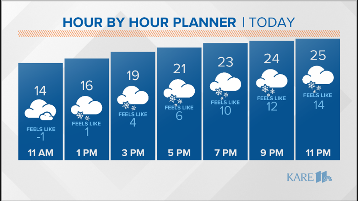
After the snow, prepare for the cold! Temperatures will plummet throughout Saturday, starting in the 20s but getting below zero by evening. The temps will stay frigid into Tuesday morning, with highs in the single digits and lows below zero. But there's hope! You can look forward to 30s by Wednesday.
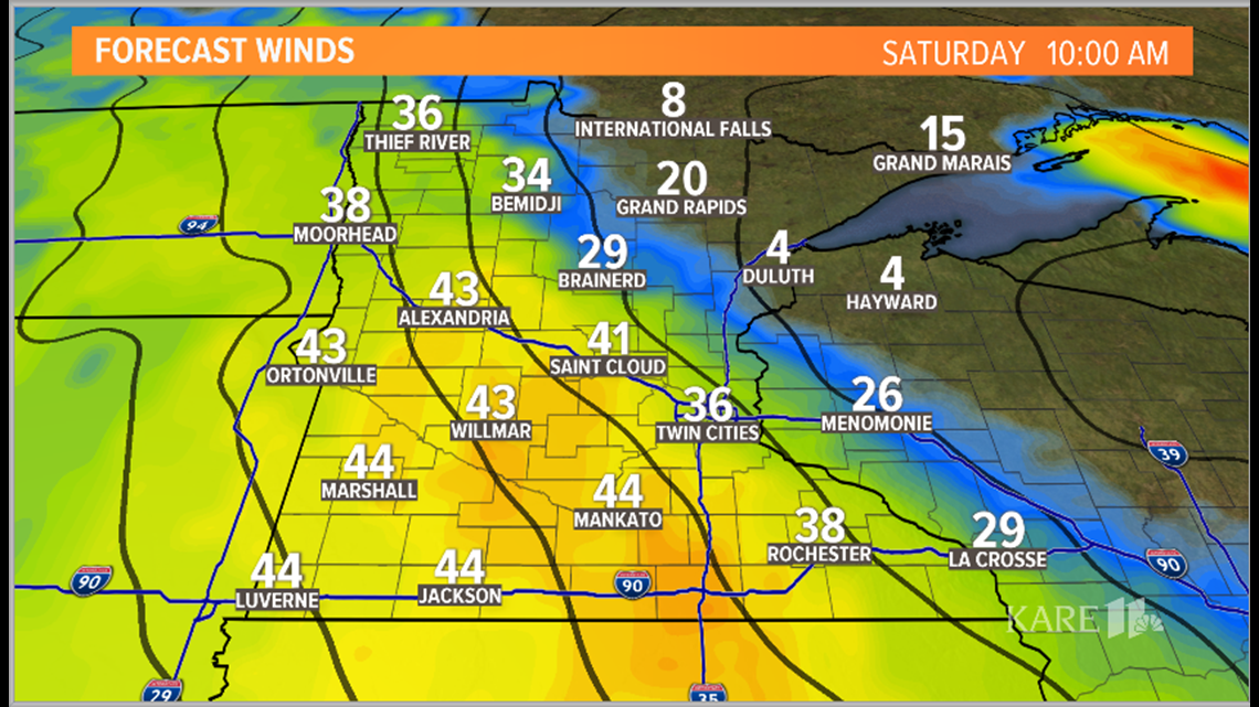
And don't forget the wind! On Friday we're expecting winds from the southeast at 15 to 20 miles per hour. Saturday, they'll be out of the northwest at 15 to 30 mph, with gusts as high as 40-50 mph.
RELATED: Snow types: Sledding or snowman?

Should I cancel my travel plans?
That depends. If you're headed west and didn't leave Thursday night, you're going to be dealing with heavy snow. Heading south into Iowa or east into Wisconsin? Leave before noon on Friday. Headed north? Leave by early afternoon on Friday. Headed up northwest on I-94? Leave Friday morning. Heavy snow will reach the corridor by about noon.
Have a flight booked? You may see delays on Friday evening at MSP. That's when we expect the heaviest snow. Find out if you are eligible for a travel waiver here, and watch below or click here for more of Laura Betker's travel advice.
Are schools closing?
We got hundreds of school closings and early closures Friday, all listed right here on our closings page. You can download the KARE 11 app to stay up to date and get alerts. How do schools decide when to close and when to stay open? Reporter Jennifer Austin dug in.
What kind of snow is it?
Is it the heavy stuff that makes great snowmen and snowwomen, but is a huge pain to shovel? Or the dry, light stuff that we love to sled on but can't throw at anyone? Fortunately for shovelers and unfortunately for some kids, it's the light stuff. Learn more about the science of snow types below or click here.
Have a weather-related closing?
If you have a school, organization or activity that you would like included in the KARE 11 closings list, fill out the form here.